Glossary entry for
Coney Island
 The following extracts are from A Journey Through Lecale by John Magee.
It is a book of approx. 90 pages featuring a collection of photographs taken
around the 1920s/30s and which are held at the Ulster Folk and Transport Museum
at Cultra, Co. Down.
The following extracts are from A Journey Through Lecale by John Magee.
It is a book of approx. 90 pages featuring a collection of photographs taken
around the 1920s/30s and which are held at the Ulster Folk and Transport Museum
at Cultra, Co. Down.
The Lecale district is a flat peninsula lying between Strangford Lough and Dundrum Bay, and bounded on the west by the Quoile and Blackstaff rivers and the marshes which until recent times almost surrounded the low hill on which Down Cathedral stands. It derives its name from the Irish Leath Chathail: Cahal's territory, but in the early annals it was frequently referred to as Magh-Inis: the insular plain. To this day [...] it is known to some of the older country people as Isle-Lecale.
A journey through Lecale takes one to some of the most varied and interesting scenery in Ireland, encompassing as it does the historic cathedral town of Downpatrick, where St. Patrick is reputed to be buried, the protected plant and animal life of the River Quoile pondage basin, drumlins with its megalithic tombs, raths (pre-historic hill forts) and stone castles, and the delightful coast with its coves, headlands and strands, stretching from Strangford through Ardglass and Coney Island, to Tyrella and Dundrum.
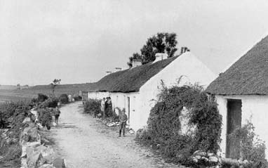
Coney Island, is not an island as most people think, but is actually a group of cottages which are just off the winding road between Ardglass and Killough [photograph shows Coney Island cottages, circa sometime between 1910 and 1930]. Its name is derived from the gaelic coinin: a rabbit, and originated from the fact that rabbits abounded in the sandhills. Originally the cottages were occupied by inshore fishermen, who sheltered behind the pier enclosing Killough harbour. The fishermen are gone now, and their cottages are refurbished and occupied during the summer months by visitors. It is an area were peace and tranquility reigns. The surroundings are magnificent, with the Green Road and Bella's Tower to the north, the coastguard house and St. John's Point lighthouse to the south, and the blue outlines of the Mourne Mountains on the skylines.
St. John's Point is a rocky headland, on which over the years many ships were wrecked. A lighthouse with a fog horn was built in 1844. In 1893 the lighthouse was raised to its present level and houses were built for the lightkeepers and their families. in 1954 the buildings were renovated and in 1980 the entire system was electrified. Despite the lighthouse, coastal hazard remain, and many in Lecale still remember the Georgetown Victory troopship with 1,500 on board, which was wrecked on Killard Point on 1 May 1946.
Ardglass, which is a lively fishing village, derives its name from the Irish ard glas : the green hill, probably a reference to the conical elevation, now known, as The Ward, to the west of the town. During the nineteenth century Ardglass became a centre of the east coast fishing industry. Population in 1851 was around 1,000, but by the turn of the century this had dropped to about 500, although this has increased over recent decades.
Killyleagh is a small town on Strangford Lough to the north of the Lecale district. Shrigley is a village about a mile and a half outside Killyleagh on the Saintfield Road on the way to Belfast.
Well that is the geographical location of "Coney Island". Many people have been confused as to the route that Van seems to have taken on his journey. I would say from the start this has largely been caused by the fact that Van changed the words in the first line from what is printed in the album. Had he sung the original words, it would have made more sense.
In the song Van sings "Coming back from Downpatrick" which gives the impression that he is heading back home to Belfast which is to the north of Downpatrick. However when he sings "stopping off at St. John's Point" things become confused as St John's Point is to the south of Downpatrick. If he had sung the original word "Coming down from Downpatrick" all would have made sense.
What some people have also tried to do is follow his route. This is not entirely possible, but why should it be. Do we always when telling someone about a trip always cover things in strict sequential order. Allow him a bit of artistic licence.
Contributed by Van list member Blair
More information available at:
- the Wikipedia page on Downpatrick, Northern Ireland
Van references in:
- "Coney Island" (on Avalon Sunset)